I really must stop wittering on about IT … well, so my lovely daughter tells me! Actually, what she said, and she and J were meticulously careful about this, was that two posts in a row about IT is as far as I can reasonably go. I know they’re right but I did turn to some R today and it went really smoothly. When you find some R code you’ve never really played with much before generates a nice picture like this from some data in someone else’s paper …
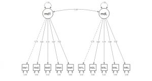
… in perhaps an hour in all from inputting the data, checking it, working out the code for this analysis (a confirmatory factor analysis or CFA if want to know, OK, I get it family: you didn’t!) … then it does remind me that there are good times working with IT and open source empires of code.
But I am disobeying a direct family order. Enough of that and finally back to last year and the ride. By the 25th I’d moved on from the Loire, I’ll go back in days ahead (this really is a time travel game) but this was the track from the 25th:
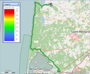
The start looks like there were two succubus inspired detours:

But that first dog’s hind leg bit was deliberate: into the local supermarket from the campsite to stock up, then a little bit that was back on my tracks and then off properly.
The next very straight detour stabbing south in that image was pure Google maps playing with me though. It/she was quite clear I should take what looked at first like a lovely, well metalled track alongside a sort of canal. The canal was, as you can see there, ruler straight and wide enough to have boats on it and what seemed like a great towpath on which to cycle … until it petered out in increasingly narrow, gravelly wreck, hopelessly hostile to cycling. I remember I was getting very battered by these experiences and I was probably audibly cursing as I turned back, what I knew was pretty much due north and completely away from the direction I wanted. I remember cycling back past calm looking men fishing whom I’d passed some minutes before and wondering what they made of this madman disturbing their zen.
I wasn’t entirely happy when I got back on the main road either as it, and the tracks I turned onto then seemed to continue to point rather more north than seemed fair. However, inevitably, we hit the Atlantic the route turned due south. Then the wonderful sun and the strange sandy, pine tree covered route helped cheer me up. I have very few ‘photos from the day, precisely six in fact, and I think it was a funny day of continuing adjustment of mood. I was fighting a nasty, niggling anxiety that I wasn’t making enough distance to make even Compostella reachable, let alone Finisterra. That meant I didn’t spend time on ‘photos.
This does give a feel of the countryside and the absence of cloud cover though:
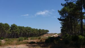
It was truly wonderful!
The green colours of my route on that map above show that the route was pretty flat all day which at the macro level was true. However, that ‘photo tells the other side of that: that the route went over sand dunes that were never actually flat but rolled up and down. The gradients were gentle but you could never see far ahead which amplified my anxieties about my slowed progress. At times I was close enough to the coast to be able to hear the waves but there was almost never a point where I could see it. I think there’s a sort of edge rib of quite high dune near the coast itself. Presumably some quirk of wind, waves and afforestation have created that.
I see I didn’t do a blog post last year for any of the 24th, 25th or the 26th. I’m not sure why. However, I see that the one from the 27th, http://www.psyctc.org/pelerinage2016/my-last-rambling-post-for-today-road-surfaces-and-tree-root-ruckling/, referred to some other challenges I hit on the 25th. One was those tree roots ruckling up the surface of the track in a way that would probably have been fun on a mountain bike with suspension, but could be a bit grinding on Toto-to-be. The other was what I called in that post “tightrope cycling” and I see I promised that I’d some day come back and explain that. Well now, a year later, I get to make good on that promise. This is a minor example:

That’s actually a lovely concrete surface but it’s quite narrow, I’d guess about 1.5m wide and that’s not a lot when you meet people on bikes coming the other way (most walkers kindly stepped off the concrete for we cyclists). You can also see two other challenges: sand.
OK, yes, I can count, I know, sand isn’t two, it’s an extraordinary number of individual grains. Ah, but it is two really when your on that trail: there is sand-on-the-side and sand-on-the-track. The sand-on-the-side means that you slow to a pretty immediate stop if you come off the concrete. That sand is soft on the top, so your wheels go in deeply immediately; however, it’s heavy and damp lower down so your wheel also stops as if you’d hauled on the brakes with all your power. You really don’t want to come off the track without at least one foot out of the pedals and ready to stabilise you. Then, and that in the ‘photo is a very minor example, there is sand-on-the-track. That was sometimes thick and completely covering the track, particularly in places where the track took some turns around trees or large rocks. That meant that you really had to have your wits about you as the sand-on-the-track was bone dry and basically turned the lovely concrete into an instant skid pan.
It was all quite enjoyable when I was doing well: I bowled along reasonably speedily and had that enjoyable experience of having to have all my wits and senses about me: look out for sand, listen out for people coming the other way hidden by trees or big rocks, hold the handlebars lightly but responsively to handle the tree root ruckles. However, it was tiring.
As the hours rolled on, I realised that I would have to stop in Biganos. I remember that I was disappointed as that was only 96km achieved in the end and I know I had had aspirations to get much further south. However, Biganos seemed a lovely name. I had difficulty finding somewhere to stay, there was no campsite (that I could find) and I remember that several cheap hotels I ‘phoned in the now rather deflating late afternoon/early evening heat were closed for the summer or full.
This was the final trail:
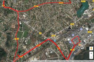
Actually, that’s not as bad as it looked. I came into the town in the top right hand corner of that satellite image. (Do you like the shift to satellite imagery? So do I! Brings things back in a very different way to the way the route maps do, or don’t. Ooops, I’m getting geeky again!) I remember that dead end to the top left was about me stopping to make ‘phone calls to find places and I remember that I found somewhere a little bit more expensive than I’d hoped for. That’s the little stub off the main road on the bottom left. That swing off along the main road, off then to the right (under a railway line I remember) and then back on myself and round a great square of car park was me going to the local supermarket to get fodder … and back to the hotel.
Now this is a Google/satellite miracle:
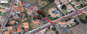
You really can see the hotel, well, you can on the original, I think this is a rather compressed version. Today I looked at it and thought “Oh no, I have no recollection of that. Surely that was a campsite?!” Gradually, and I think the fact that I could zoom in and see this level of detail …
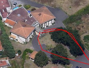
… cracked the ageing memory and suddenly I could remember the hotel, remember the lass behind the counter in that central atrium who told me that the supermarket was really my best hope for food. I can remember the room on the ground floor in that right hand square wing of the hotel. I can even remember, vaguely, two sets of car conveyed fellow guests who arrived after me. It’s funny stuff memory isn’t it? It’s a funny but amazing realm this of the human wetware, who would waste time with hardward and “soft”ware when they have wetware in their own cranium and the chance to talk with other wetware engines walking around the world?! The family were right all along!
Enough for today. I think I shall sleep well tonight, reconnected with the pelerinage after the recent disconnection. Good enough wetware work for one virtual pelerinage!